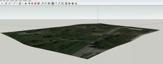
How to Import a Map with Google Earth Terrain into Sketchup

The process of importing google earth terrain and/or map into sketchup is pretty seamless (probably because when google first acquired sketchup they were hoping to use it to populate the 3d buildings in google earth). So lets get right to it.
Once you generally know where your site location is, open sketchup, hit the file tab and scroll down to Geo-location>Add Location… from here you can search as you would in google maps for your site. For example if you wanted to search for a site in Philadelphia, you could type in Philadelphia, PA to start panning around to find what your looking for. You can also enter a specific address if you have that as well.
Once you’ve found your site, you need to decide if you want more contextual (broader) information on your site or more detailed information.
Broader information is the way to go if you don’t plan on modelling the site, or you’re in a rural setting with not much around to be too concerned about.
More detailed information is helpful for the opposite; if you plan on modelling the site and/or it’s in a dense urban context.
Once you’ve decided on what kind of information you want, you’ll know how to set your zoom. A close-up zoom is what you should use to get more detailed information and a zoomed-out view is what you should use to get broad information.
Use the pins to change the area you’d like to import to your model. Hit grab once you’re satisfied by your selection to import into your modelling space.
If you are kind of an information pirate like I am and want to have the most site information possible (or you find you want to expand your site), that’s easy to do. Simply go back to to File>Geo-location>Add Imagery to expand your site with additional imagery.

Lastly, to toggle the 3d site terrain on and off go to File>Geo-location>Show Terrain.
If you found this sketchup tutorial on how to import a google map with terrain helpful please like and share it.
Until next time. Happy hacking.

Thanks Dennis!
I wasn’t aware that you could ever bring in more than just the topography. As far back as I can remember all that comes over is the topography.
There used to be some work-arounds for this with something called a “3d print screen” but last I tried, this no longer works. That may be an avenue worth looking into though.
It’s not getting the 3D terrain. For example, in GEP, I can see my house and the surrounding trees. However, when I load my house location into Sketchup, all that Show Terrain shows is the slope of the ground.
Also, the pins don’t work, so I have to grab the entire view, including the Google footer.
(I’ve read that Google doesn’t allow 3D terrain to be exported anymore. Which seems to be the case, because the KMZ files produced by GEP don’t contain the Collada data mentioned in the documentation. I guess Sketchup can’t find it either.)
I’m glad I could help Dennis!
Thanks a lot, you helped me out, the terrain option was hard to find in new versions of sketchup, they got rid of the terrain map
In theory you can zoom the farthest out sketchup will let you zoom and then patch in multiple maps. However, I don’t think Sketchup was designed for models of this magnitude.
You can add more than one geo-location. Just keep ‘adding imagery’. I can’t promise that the program won’t crash though.
hello! I should grab the entire terrain model of Istanbul, which is a
way much more big then the selection area allowed from sketchup. Is
there a way to do that?